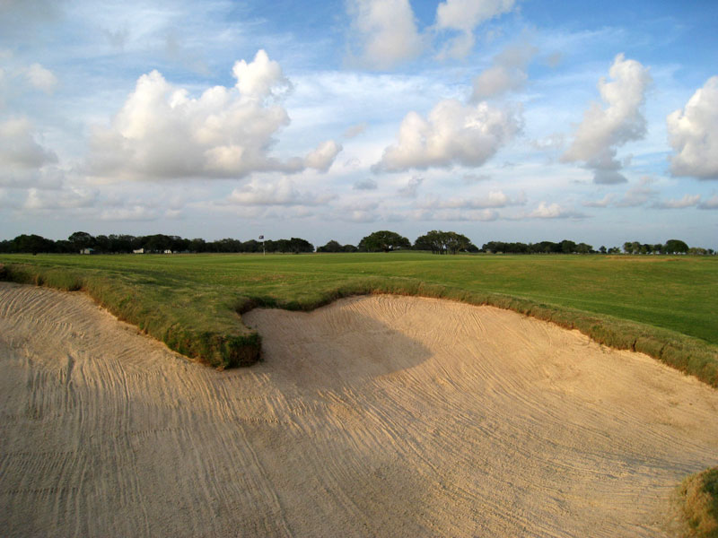
 This bunker has a bit of a different look as compared with some from earlier. The first tee shot of the day will usually contend with this bunker. If you carry it the flag is not far beyond.
Monday, July 28, 2008
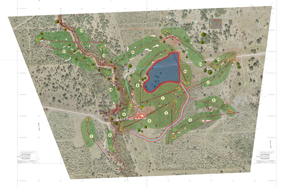
Bunker on the first
This bunker has a bit of a different look as compared with some from earlier. The first tee shot of the day will usually contend with this bunker. If you carry it the flag is not far beyond.
Friday, July 25, 2008
#9 almost ready
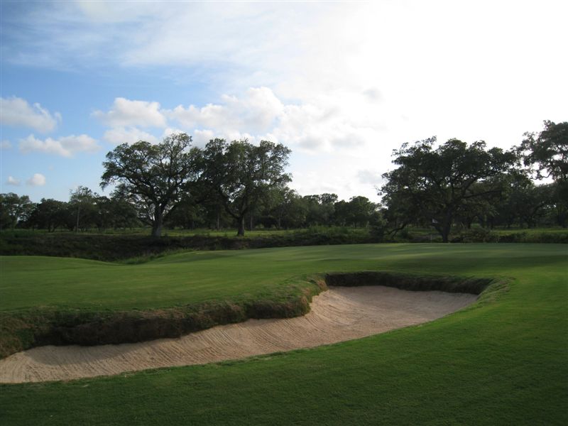
 The above picture is taken from on the 9th green towards the main clubhouse - the tee is just in front. The green is growning in well. The fairway wraps around the lake. It is one of the first pictures I've taken of the hole. I have a good idea on how I'm going to photograph it when it's ready. Taking as many pictures as I do - I'm often planning out future shots. Next time I shoot this image I'm going to make sure the whole fairway is in view.
Wednesday, July 23, 2008
4 months in...
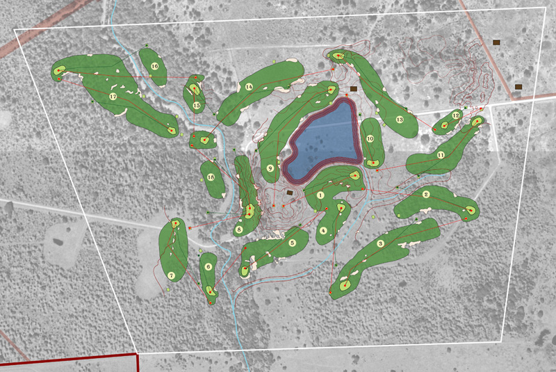
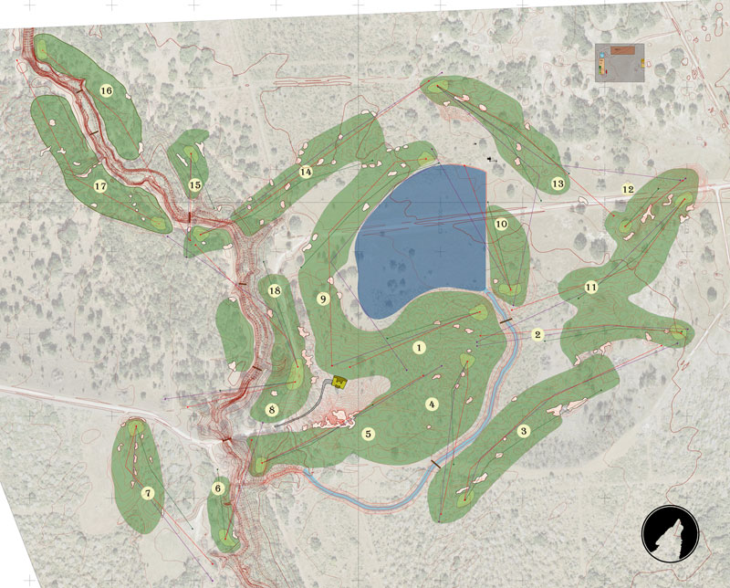 Routing 10 can be seen above. We started clearing and some preliminary site work - we were looking to find all the sand. There was a great deal of sand beneath a layer of clay throughout the site. We were looking for the best sand.
The biggest change is the new loop of 15-17. It now goes around the creek counter-clockwise. This is still a proposal and we didn't commit to this version until several months later. We started construction in the ranch and by the time we got to the creek we decided. This was a definate benefit of building it slowly - it was much easier to make changes based on how the course was developing.
“The ultimate character of the course must be developed as the construction progresses” - William Flynn
Another major change was the conjoining of holes 2 & 11. It was the repositioning of the 3rd hole to make use of a nice stand of trees that drove the shift. And the benefit was a really large fairway. The left side of #3 also became much straighter. The goal being when standing on the tee the green looks like it is sitting directly on top of the fairway bunkers - along the line of charm.
You may also notice a lot of bunkers out there - that have been shrinking and shifting quite a bit - for now they are just looking good on the page - we will build what makes the most sense in the field.
I have a few more routings to share and will continue to discuss the evolution as recently published in Paul Daley's new Golf Architecture - A Worldwide Perspective.
Monday, July 21, 2008
The bunker you can see is much worse...
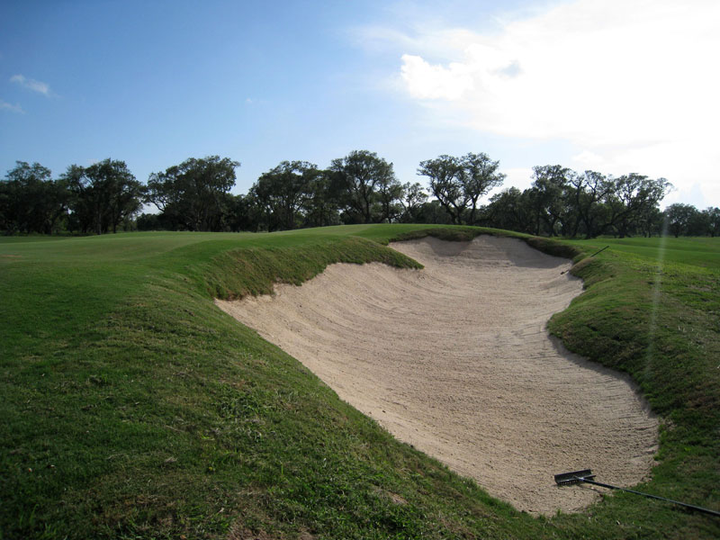 This is the bunker that you can see from the 14th approach - here was an earlier blog entry. Please notice the rakes, I usually hide them for the pics, but in this case they give good scale to the bunker - it is pretty deep - and the creek is directly to the right.
Windy as The Open
 That was some great playing by Harrington yesterday. I wish more courses were left alone to play with the elements. Sometimes it will be easier, sometimes it will be too hard. Some days Wolf Point is easier and somedays it is harder - the wind is the biggest variable, followed closely by pin location and firmness.
Above is a picture of the bunker hidden by the 14th green. The view is looking back towards the live oak in the middle of the fairway.
More routings tomorrow.
Thursday, July 17, 2008
Routing Plan #9B an interesting choice
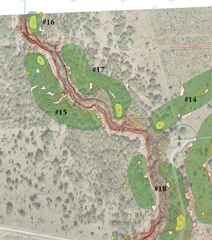
I like triangulation - when 3 holes make a small loop. They head in different directions and allow for different orders of playing the holes - as multiple greens and tees meet at congregation points. Routing plan 9b came about at the same time as routing plan #9 and flipped the triangle of 15, 16 & 17. Making this sort of adjustment is also an advantage of using small loops.
In this version the 14th hole was shortend from a par 5 to a par 4 with the green on the near side of the creek - it would be a nice green site on either side. I liked the non-forced carry of the 14th as a par 4. This would change both the orientation of the next 3 holes relative to the creek - the hazzard would be on the fade / slice / right side of the player - and change the par sequence from 3,5,4 to 4,3,4. The teeing location for 18 would also change slightly - but not the fairway.
Negatives: 14, 15, 17 & 18 would all be par 4s - I'm striving for as much variety as possible - and this would be a tiny negative. The 16th green was going to be too close to the property line.
Positives: Changing #16 - I do not like this hole on plan 9 - it seems a little forced - and it was as I forced the green down away from the property line. Don liked the natural look of the holes on this version.
To this point my client was not involved in the "design" of the course. I wanted to get him more engaged in the process - to include his preferences and hopefully like the finished product that much more - he chose plan 9 over this version. He liked the forced cary to the green over the creek. While his first remarks were to make the course fun, he had since been very encouraging of making it challenging - with a home field advantage.
There are bits of stragey from great golf courses imbued in Wolf Point Club - NGLA - Seminole - The Old Course - Royal County Down - and it wasn't until several months later that I learned what other course had an influence on Wolf Point Club. Our client chose the green location for its difficulty but it was also similar to a hole he had been playing recently. Maybe one day I'll add the name of the course to the end of the above list - but not any time soon.
With hindsight and a better understanding of the land - this loop of holes would have been excellent too - I'd have loved to played them.
ENJOY THE OPEN!
The the next several posts I'll continue to discuss the evolution of the routing plan at Wolf Point Club as recently published in Paul Daley's new Golf Architecture - A Worldwide Perspective.
Monday, July 14, 2008
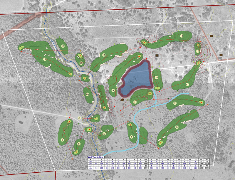
Routing Plan #9 new aerial & topographic map
The first difference I notice with this routing plan (#9 which is about 2+ months in) from routing plan #6 is that I'm working with a new aerial photo and topographic map. The site was flown and the stero photographs were compiled into a 1' contour map. Having this detial alows for more efficient planning of drainage, irrigation and earthwork. It is a necessity. Another addition is I've located some specimen trees via GPS - I walk around the site mapping interesting features - drainage swales, green locations and nice trees. This is also about the time where I started walking the site with the above plan incorporated into the GPS receiver - so as I always know where I am relative to the yet to be built golf holes. I can stand on the planned 5th green location before we start - and make any adjustments or keep it as planned.
The maintenance facility is also more refined - Don Mahaffey was definately involved at this point prior to moving down to Texas. The location for the facility was close enough and also had two major benefits - hidden from the course and has good access from the road. It was a natural clearing just the right size - so we also didn't have to clear at all.
Another refinement was the finalization of the access road and the main clubhouse. In version 6 the clubhouse is closer to the lake - which was more in line with the building architects original plans - more on a bluff. With the 2 options in hand our client chose what I now consider to be the best option. The four holes surrounding the clubhouse have conjoined even more than before and form one of the biggest lawns I've ever seen.
The 7th hole was also shifted to allow the current road to provide access. This would also create an entrance road that winds surreptitiously around the property before entering in the back of the golf course - it creates a very cool reveal - which is a foreshadowing for the reveal when you travel through the clubhouse to the above mentioned view.
The 9th and 14th fairways have also started to touch - they will do more so as we evolve. With more time on site the strategy of the 5th hole can be accomplished without any green side bunkers - the green site is surrounded by natural drainage swales - these land forms would be used as a style for areas that needed to be created.
I have lots of great new pictures from my last two visits and also a couple more birdies to talk about - there are 2 more holes in play.
The the next several posts I'll continue to discuss the evolution of the routing plan at Wolf Point Club as recently published in Paul Daley's new Golf Architecture - A Worldwide Perspective.
Friday, July 11, 2008
Bunkers getting deeper
 Pictured above is the 16th green with a bunker that protects much of the green on the right. The hole rewards a tee shot that plays to the left - or the fairway near the creek.
Thursday, July 10, 2008
15th from the ball's perspective
 I took a new digital camera to the course for the first time yesterday. A lot of experimenting - I thought the effect was pretty good. The picture is from the back of the 15th green towards a front middle pin. There is a large swale between me and the hole.
I'll make a post about the cameras as I learn more about them - every picture I've taken of the course was with an inexpensive pocket digital camera - and my new one is only slightly different.
I'll be back to the routings on Monday.
Sunday, July 6, 2008
Golf Course Routing Plan #6
My conceptual design work stays in one file. I create many simple schematics of hole centerlines before I commit to any type of strategy or detail, like fairways. I keep all my iterations on separate layers and can easily track the order and see other versions at any time. Between looking at older versions and working on new concepts - plan 6 from above was sketched - not too long after plan 5. To a casual observer it may appear as if the changes were only minor - but with the knowledge of how the holes turned out - this was a huge jump.
One item I haven't discussed much is how much earth was moved during the creation of Wolf Point Club. Hurricane Rita hit Texas between routing versions 2 and 5 and it was requested to raise the main clubhouse in case "the" big one ever made a direct hit. At one point the Rita's path was tracking directly towards the ranch. I wouldn't have suggested it from a golf perspective, and it was impossible to suggest an alternative given the location and all the freedom I'd been given to that point. The lake keeps getting bigger to get the clubhouse higher.
The most obvious change from 5 was the orientation of holes 12 and 13. The intent was to have 11 & 12 use a single land form as a feature and then 13 flipped over. A small point but you'll see a small rectange - pump house location - on the lake edge inside the holes.
I started to condense the routing and got the 4th and 1st fairways to touch - which caused the 2nd and 3rd to shift tighter as well - while not a big deal in this version - this compression trend has lead to one very unique setting.
I think the condensing came about because of how I modified the 5th hole. What ever came first, the 5th hole became world class because of the change. At this stage the green site is based on a great location from walking the property. The inspiration for the hole may be recognizable based on the bunkering. Can you guess?
I continued with the compressing of the course to shorten the walks from every green to the next tee. As a result I shifted the 7th hole and progressively shifted the 8th green towards the 9th tee. One day I took a big gulp and decided to try combining the 8th and 18th greens. I say gulp because I've seen so many poor versions of a double green where they may be artificially connected by a sliver of green grass. These were going to form one large oval and be separated by a swale. Pictures of the green are almost ready to show - it is very impressive.
For the next several posts I'll be detailing the evolution of the routing plan at Wolf Point Club as recently published in Paul Daley's new Golf Architecture - A Worldwide Perspective.
Wednesday, July 2, 2008
Routing Plan #5 - East to West
 Fast forward two months and I had the above routing plan - it is more than the 5th version, but I number them like software with only major changes getting a new number. The request after my initial plan was to have to the course follow a more east to west orientation and the ranch would be a significant part of the course.
Initially I considered keeping the irrigation lake away from the course - but with not many major features it seemed that it would be best for this client - so I kept the lake large - actually alittle bigger from the first version to create a sence of place.
After several more visits the above plan was created. I drew up an artificial boundary - white trapezoidal line above - to keep away from the property lines and to give myself a target area to work in - with too much space it can be hard to visualize the best locations. I had visited Seminole Golf Club during this time because of some potentially similar terrain - Seminole's property is a trapezoid with each nine split in a triangle.
I created a ditch to act as an outfall, and tried to create as many strategic fairways as possible. I overdid it and spent the next several versions backing off the diagonal carries. There were 5 fairways with two landing areas - as a hint: the only one that remains is the 18th hole with the creek running down the middle.
I was very happy with the way the holes started in the ranch, moved towards the creek, back to the ranch and finished along the creek - it could make for good transitions and wouldn't create a ranch nine and a creek nine. I was still focused on getting the course to the nice motts of live oaks in the north west corner.
The brown squares are the clubhouse, pump house and maintenance facilities - moving left to right.
For the next two weeks I'll be detailing the evolution of the routing plan at Wolf Point Club as recently published in Paul Daley's new Golf Architecture - A Worldwide Perspective.
Subscribe to:
Posts (Atom)